MapmyIndia

Speed & Traffic Pattern

To avoid traffic congestions and keep traffic moving, the enterprises and public authorities advocate policies for smart and flexible use of the road capacity. The Speed and Traffic pattern derived from Traffic data and/or GPS probes datasets are geo referenced to Map database to help the authorities to make informed decisions for planning traffic situations.

Traffic Management Platform

Visualize instantly the flow speeds (colour of the roads) and traffic congestion events (icons) in real-time in a web browser on top of existing road layers of MapmyIndia maps

  • Provides 24 by 7 real time updated Traffic data
  • Coverage – Pan India Identifies Traffic Bottlenecks
  • Predicts the traffic situation to help analyse the road trips in advance
  • Estimated travel time information
  • Other services like map navigation helps the driver to find nearest POI, check alternate routes and know the distance to destination

APIs to support applications for consumers and enterprises

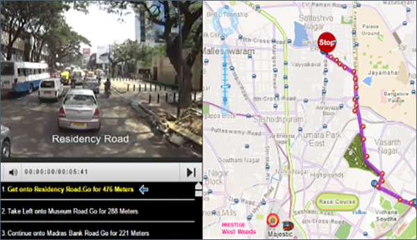
MapmyIndia’s powerful API’s helps to create engaging web and mobile applications with best routes with current traffic conditions in real time.

  • Color-coded traffic for quick visual status of traffic problems
  • Identifies where, when and why traffic congestion occurs
  • Real-time traffic data is aggregated and analyzed from sophisticated and high-quality rich vehicle sensor data with historic and real time traffic feeds.
  • Traffic APIs help you to get flow and events data
  • High-quality maps to give accurate road map
  • Live traffic feeds through connected car probes
  • Aggregates and processes probes using various industry standard formats like TMC & open LR to deliver the most accurate traffic service to our customers.
  • Premium attributes - Affluence, age group & socio eco data
  • Vehicle Population