
Smart Street Lighting for a Smarter City
Street lights are among a City’s most important assets, providing safe soads, safe citizen areas & enhanced security. As the Municipal departments are investing heavily on Planning, Establishment & Maintenance of Street Lights, it is essential to have an Intelligent Geographic Information System (GIS) in place. In order to bring efficiency, accountability & transparency in the entire process, a comprehensive GIS-based Street Light Information System will be formulated & adopted to ensure that street lights are in good conditions at all times.
Usually Municipal Corporations do not have comprehensive database of Street Lights under their jurisdictions & historical data on the Street Lights are being maintained in files. Top officials of corporations face stiff challenges in obtaining information on historical maintenance records, ongoing and completed street light maintenance activities, for example - present conditions of the street lights - to make decisions.
MapmyIndia’s best-in-class map & location technology can develop comprehensive GIS Databases of all the Street Lights under Municipal limits through Field survey & Mapping and implement a comprehensive Street Light Information System to introduce efficiencies into the system.
Key Components of Smart Street Lighting:
- Creation of Street Lights Geographic Information System (GIS), by porting the datasets collected through Field Survey & Digitization into a Centralized Geospatial Database.
- Integration of all essential physical characteristics of the Street Lights as attribute information.
- Designing, Development & Web-based Implementation of Street Light Information System to support all day-to-day activities of Street Light maintenance & management.
- Mechanism for updating maintenance details of Street Lights & tracking of service history.
Key Features are as Follows:
| S.No. | Feature Description |
|---|---|
| 1. | Authentication-based Access for Municipal Officials |
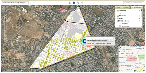
| 2. | Interactive Map Display with Online Basemaps, Overview Map, Scale Bar, North Indicator & Common Map Navigation Tools (such as Zoom Slider, Zoom In, Zoom Out, Pan, Previous Extent, Default View) |
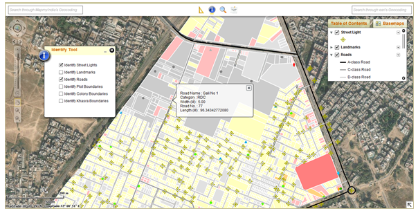
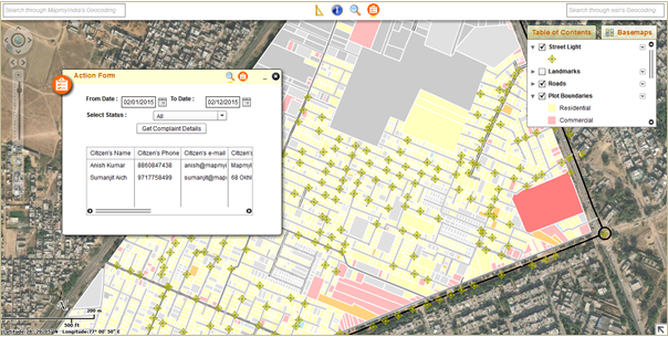
| 3. | Identification Tool for Important Map Layers (such as Roads, Plots, Street Lights), which will Select Feature on Map View & Display its Attributes on MapTip |
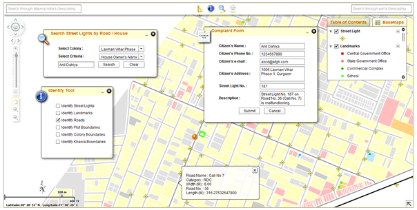
| 4. | Search Tool by Auto-populated Road Name, Road No. which will allow easy recognition of Street Lights in vicinity (~ 10 m) of Roads |
| 5. | Progress Monitoring of Street Light Maintenance Activities through Query Results |
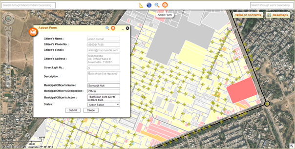
| 6. | Access to Maintenance Information of Street Lights with a single mouse-click |
Benefits
- The Software Application Product helps Municipal Agencies to increase its efficiency in handling day-to-day activities on Planning, Monitoring & Maintenance of the Street Lights within their jurisdictions.
- We provide quick GIS-based Visualization & Information on Street Lights to the top officials at a fingertip.
- Officials have access to all the Street Light-related Information within a single repository, which will eventually help in planning for establishment of new street lights.
- Scheduling & tracking of Street Light operation & maintenance work.
Sample Screenshots


Request Call Back
There's so much that Mappls MapmyIndia can do for your enterprise or individual requirements. Explore our website to learn more or request a callback/email if you'd like us to connect with you.
or