-
Products
Products
- Map and Data
Map and Data
-
![]() Map
Data
Map
Data
Location data reflecting the real world
![]() Geo-demographic
Data
Geo-demographic
Data
Updated, reliable, industry data
![]() RealView
RealView360° panoramic street images
![]() Map Portal
Map Portal
India’s original internet mapping portal
![]() eLoc
eLoc
Doorstep digital address system
![]() HD Maps
HD Maps High precision 4D maps
![]() Metaverse 4D Maps
Metaverse 4D Maps Immersive maps reflecting the real-world
-
- APIs and SDKs
APIs and SDKs
-
![]() See all APIs
See all APIs 
Explore our entire suite of APIs & SDKs
![]() Maps
Maps
SDKs for maps and traffic
![]() Search & Geocoding
Search & Geocoding
APIs for search and discovery
-
![]() Routes & Navigation
Routes & Navigation
APIs to solve complex routing problems
-
![]() Navigation SDK
Navigation SDK
Connected embedded navigation
![]() Mobility & Tracking
Mobility & Tracking
SDK to enable live location in your apps
-
![]() Global APIs
Global APIs
Maps, search, routes for 238 nations
![]() Personalisation SDK
Personalisation SDK
Hyperlocal, personalised O2O marketing
-
![]() Optimisation APIs & SDKs
Optimisation APIs & SDKs
Route planning & optimisation
![]() GIS and Analytics APIs
GIS and Analytics APIs
GeoBI meets Location AI
![]() Workmate APIs
Workmate APIs
Field force automation APIs
![]() MapmyIndia Move URLs
MapmyIndia Move URLs
Embed maps, navigation in your apps
![]() NaviMaps SDK APIs
NaviMaps SDK APIs
Hybrid navgation for embedded systems
-
See all
APIs
![arrow]()
-
- GIS, Analytics and AI
- IoT and Automation
- Navigation and Mobility
Navigation and Mobility
![]() NCASE Automotive Suite
NCASE Automotive Suite
Intelligent mobility platform for PV, CV, EV
![]() Navimaps
Navimaps
Offline navigation maps and app
![]() Mappls App
Mappls App
Super app for maps, safety, and more
![]() Mappls Gadgets
Mappls Gadgets
GPS enabled IoT gadgets
-
![]() Navigation SDK
Navigation SDK
Connected embedded navigation
![]() Traffic AI (coming soon)
Traffic AI (coming soon)
Convert movement data to traffic analytics
- Drone Services
- Map and Data
- Solutions
- Consumer
- Developers
- Investors
-
 Drone Innovation Challenge
MapmyIndia launches Drone Innovation Challenge 1.0, in partnership with Drone Federation of India (DFI), to promote the creation and growth of India's drone ecosystem.
Opportunities worth up to Rs 1 crore or above available to winners!
India’s burgeoning drone market
India is said to be the fastest growing drone market in the world.
Unmanned aerial vehicles (UAVs) or drones are used to perform various activities, such as video/photography, mapping, surveillance, deliveries, spraying insecticides, and more.
According to a January 2020 PwC report, India’s drone market is predicted to hit $885 million by 2021 and further explode to $1.8 billion by FY 2026, growing at a CAGR (compound annual growth rate) of 14.61%.
Solutions for Drones
Map APIs & SDKs
Get limitless location-based data points and insights by integrating our Map APIs & SDKs.
- Simulate the flight path that your drone took while flying over a city or terrain
- Ingest custom point cloud datasets captured through drone mapping into our existing maps SDK
- Visualise the historical flight path of your drone and render it on a map
- Get ground/sea level elevation of your drone to plan accurate survey flight paths
- Integrate Map APIs into your flight planning software
- Easily create and render ‘no fly zones’ on a map
-
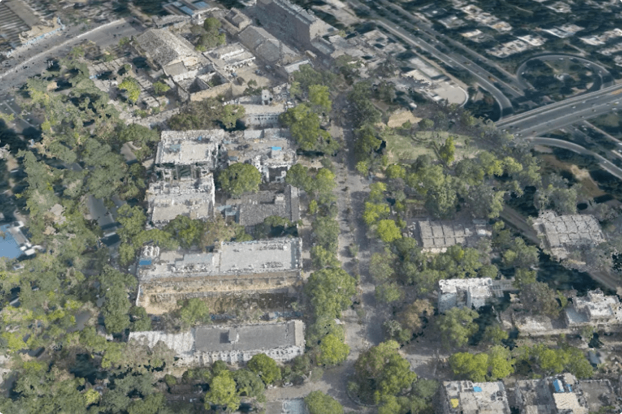 Point Cloud - Ingest Your Own Point Cloud Datasets
 -
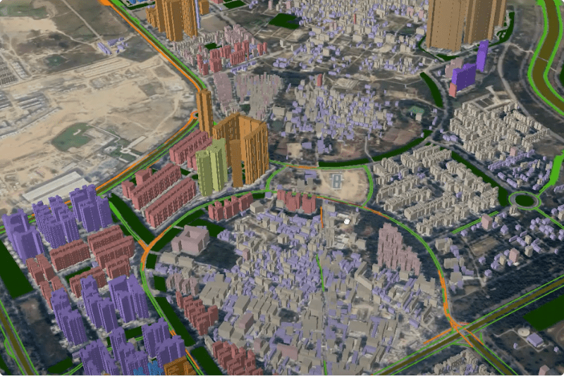 3D City Models
 -
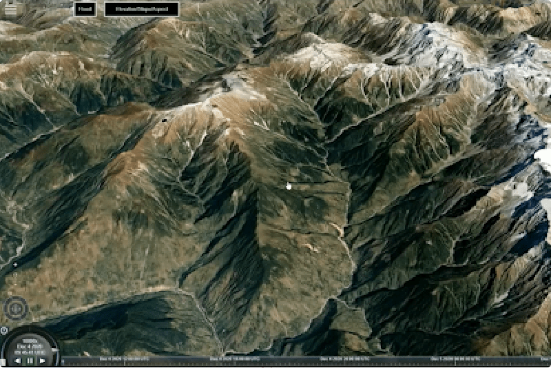 Realistic 3D Terrain Visualization
 -
 Geofence
mGIS
Advanced geoanalytics that combines custom drone imagery, point cloud datasets with MapmyIndia’s ready-to-use rich 2D & 3D map datasets.
- Visualise and analyse the ingested point cloud datasets captured through your drones
- Identifying areas for surveying and mapping activities (natural resources, agriculture etc.)
- Add your drone survey data to our GIS tool and run advanced geoanalytics on it
- Create and simulate flight paths on 2D & 3D maps of city models or terrain
- Take into account obstacles like buildings, bridges, streetlights etc. to create safer flight paths
-
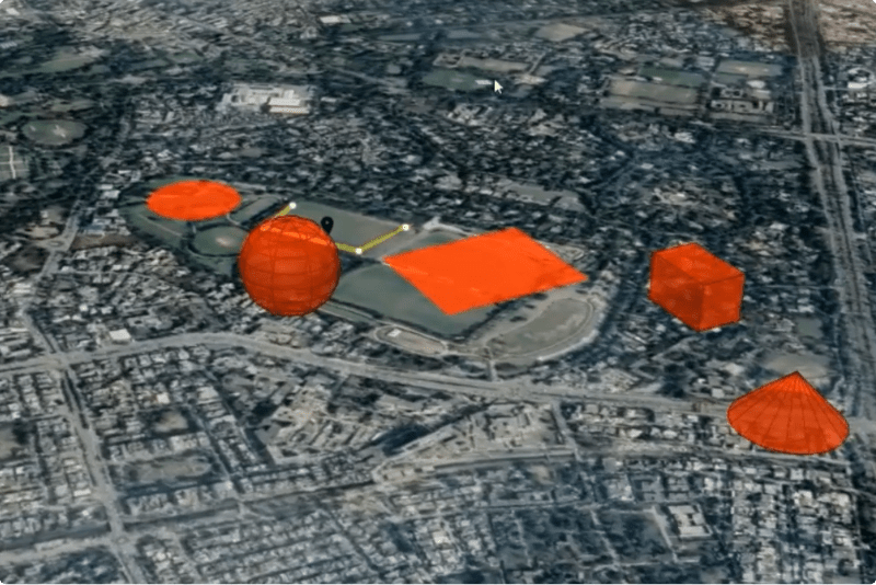 3D and 2D Object Overlays On Maps
 -
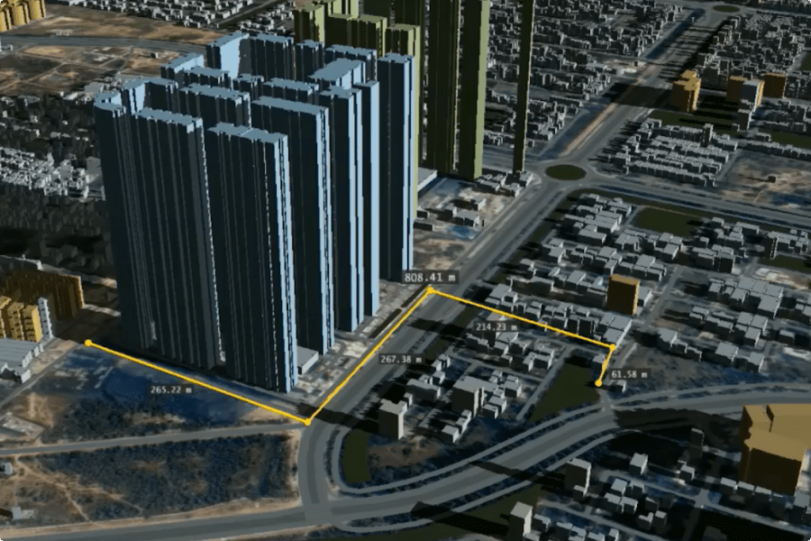 Arithmetic Measurements Capability
IoT Platform & Devices
Ensure your drone operations are in compliance with GoI regulations
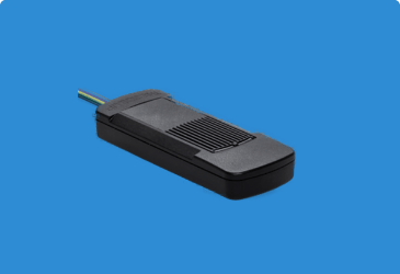
Hardware

Standalone
Standalone Battery Operated GNSS Hardware + Mobile App + Web App + Data Transfer through API
- Device will take power from its internal on-board battery
- This is a standalone hardware and requires no connection to the drone
- Velcro may be used for installation
Deep installed
Deep Installed GNSS Hardware with Remote Drone Control + Mobile App + Web App
- Device will take power from drone’s on-board battery
- Switches to internal battery when power gets disconnected from drone’s battery
- Velcro may be used for installation
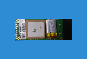
Integrated
Integrated GNSS Hardware (Bare PCB of the device) with Remote Drone Control + Mobile App + Web App
- Device will take power from drone’s on-board battery
- Switches to internal battery when power gets disconnected from drone’s battery
- Velcro may be used for installation
Software
InTouch - MapmyIndia’s proprietary IoT & Telematics platform - is India’s
most efficient,
reliable and robust
cloud platform that bridges the physical
and digital world through connected devices, sensors,
and data network
Configurable dashboard that provides information about –
- Real time Status of Drones
- Active Alerts
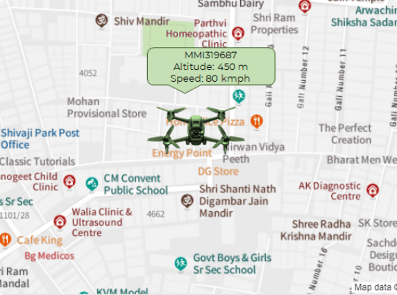
Live tracking
- Drone Status - Moving | Idle | Stopped
- Track individual drone
- Drone level information like – Location, Speed, Altitude, Drone battery power status
- GPS Device status like – GPS acquisition time, GPSR transmission time, Device internal battery voltage
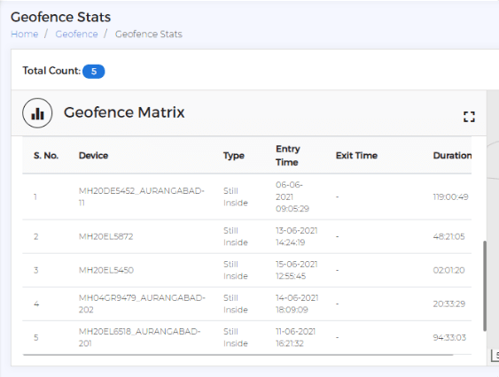
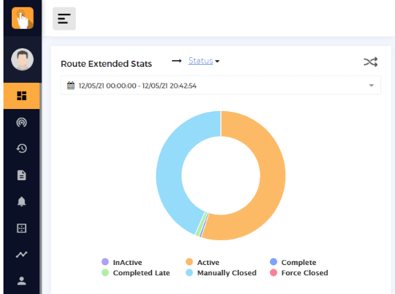
Geofence, geofence statistics
- Different types of geofences to suit different requirements
- Easy and quick to create geofence, even from live location
- Create geofences for: Unauthorized flying zones, authorized area of operation, nearby airstrips, high tension wires, and more
- Get geofence statistics for: no. of drones inside and outside authorized flying zone, flying duration inside and outside the zone, precise entry and exit time for each of the drones, flying altitude, instantaneous alert notification through email & SMS upon entry or exit of drone into a geofence
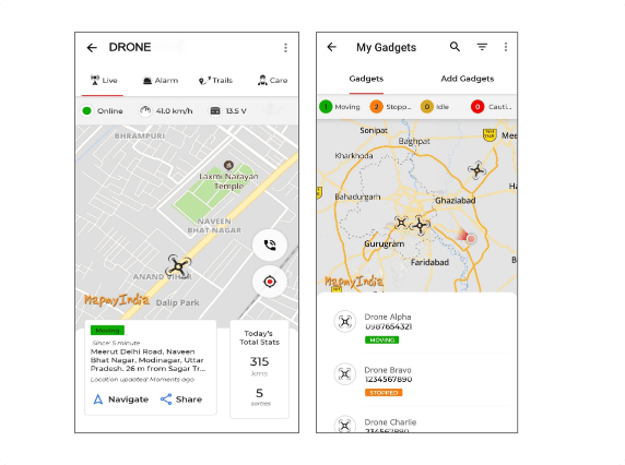
MapmyIndia mobile app
Works on both iOS and Android
- Live location of drone with details like altitude, speed, location, battery status
- Information on whether drone is inside/ outside authorized flying zone
- Geofence statistics: precise date and time of geofence entry or exit, duration inside geofence, distance of different zones from geofence


