-
Products
Products
- Map and Data
Map and Data
-
![]() Map
Data
Map
Data
Location data reflecting the real world
![]() Geo-demographic
Data
Geo-demographic
Data
Updated, reliable, industry data
![]() RealView
RealView360° panoramic street images
![]() Map Portal
Map Portal
India’s original internet mapping portal
![]() eLoc
eLoc
Doorstep digital address system
![]() HD Maps
HD Maps High precision 4D maps
![]() Metaverse 4D Maps
Metaverse 4D Maps Immersive maps reflecting the real-world
-
- APIs and SDKs
APIs and SDKs
-
![]() See all APIs
See all APIs 
Explore our entire suite of APIs & SDKs
![]() Maps
Maps
SDKs for maps and traffic
![]() Search & Geocoding
Search & Geocoding
APIs for search and discovery
-
![]() Routes & Navigation
Routes & Navigation
APIs to solve complex routing problems
-
![]() Navigation SDK
Navigation SDK
Connected embedded navigation
![]() Mobility & Tracking
Mobility & Tracking
SDK to enable live location in your apps
-
![]() Global APIs
Global APIs
Maps, search, routes for 238 nations
![]() Personalisation SDK
Personalisation SDK
Hyperlocal, personalised O2O marketing
-
![]() Optimisation APIs & SDKs
Optimisation APIs & SDKs
Route planning & optimisation
![]() GIS and Analytics APIs
GIS and Analytics APIs
GeoBI meets Location AI
![]() Workmate APIs
Workmate APIs
Field force automation APIs
![]() MapmyIndia Move URLs
MapmyIndia Move URLs
Embed maps, navigation in your apps
![]() NaviMaps SDK APIs
NaviMaps SDK APIs
Hybrid navgation for embedded systems
-
See all
APIs
![arrow]()
-
- GIS, Analytics and AI
- IoT and Automation
- Navigation and Mobility
Navigation and Mobility
![]() NCASE Automotive Suite
NCASE Automotive Suite
Intelligent mobility platform for PV, CV, EV
![]() Navimaps
Navimaps
Offline navigation maps and app
![]() Mappls App
Mappls App
Super app for maps, safety, and more
![]() Mappls Gadgets
Mappls Gadgets
GPS enabled IoT gadgets
-
![]() Navigation SDK
Navigation SDK
Connected embedded navigation
![]() Traffic AI (coming soon)
Traffic AI (coming soon)
Convert movement data to traffic analytics
- Drone Services
- Map and Data
- Solutions
- Consumer
- Developers
- Investors
Our HD Map Capabilities
Location data has propelled the technological advancements in Autonomous Driving - and with the advent of Artificial Intelligence and Machine learning, the control has been gradually moving from humans to machines. Autonomous driving systems leverage multiple sensors working in cohesion to build surrounding context, vision and intuitiveness for decision making by a vehicle.
Detailed, precise and accurate high definition maps aids in the creation of a human-like context to what the car sensors are seeing. HD maps create a 3D view of their environment that are accurate at a centimetre level.
HD Map Characteristics
- Precision at a centimetre level
- AI-assisted processing pipeline
- Industry-standard HD map formats
- Support for autonomous vehicle scenarios
- Updated data with a high level of detail
HD Map Applications in Autonomous Driving

Extend vehicle sensor
field of view
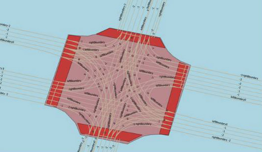
HD maps capture lane geometries, borders, traffic signs, localisation objects, and road furniture - enabling an extended, global and more human-like context to an automated vehicle.

Refine localisation of vehicle
to precise location
HD maps enable self-driving vehicles to determine their position through the localisation process precisely by eliminating the noise and merging data from different sensors.

Improve sensor
perception
Vision sensors can’t detect objects beyond a certain range. HD maps become greatly useful in such circumstances with detailed information about the surrounding environment.

Safer path planning
HD maps help vehicles find driving path options using intricate lane-level map geometries, connections, and junctions. Additional information on traffic signs helps in defining response scenarios.
What We Offer
HD Maps
Specifically designed for self-driving cars, we offer comprehensive, accurate and updated HD maps. The maps are available in industry-standard format but we also offer custom format transformations. Ready-to-use HD maps are available and we can also create HD maps for customer-specific regions of interest.
Data Acquisition and Processing
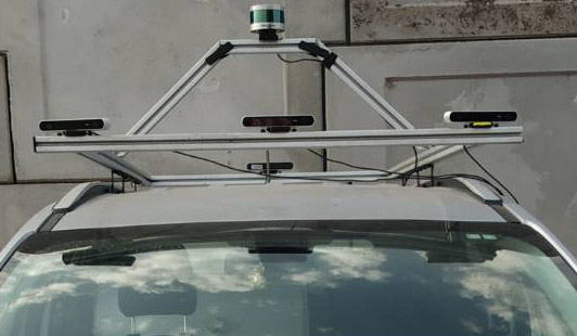
We offer a complete solution of HD map data acquisition and processing using our state-of-the-art mapping survey technology. Our survey system is engineered with multiple sensors like lidar, cameras, GPS, OBD port and processing units. The construction, architecture and cost of the system are designed to accommodate multiple sensor specifications. A portable system designed for multiple car make and model with easy configuration is suited for use globally.
Testing and Simulation
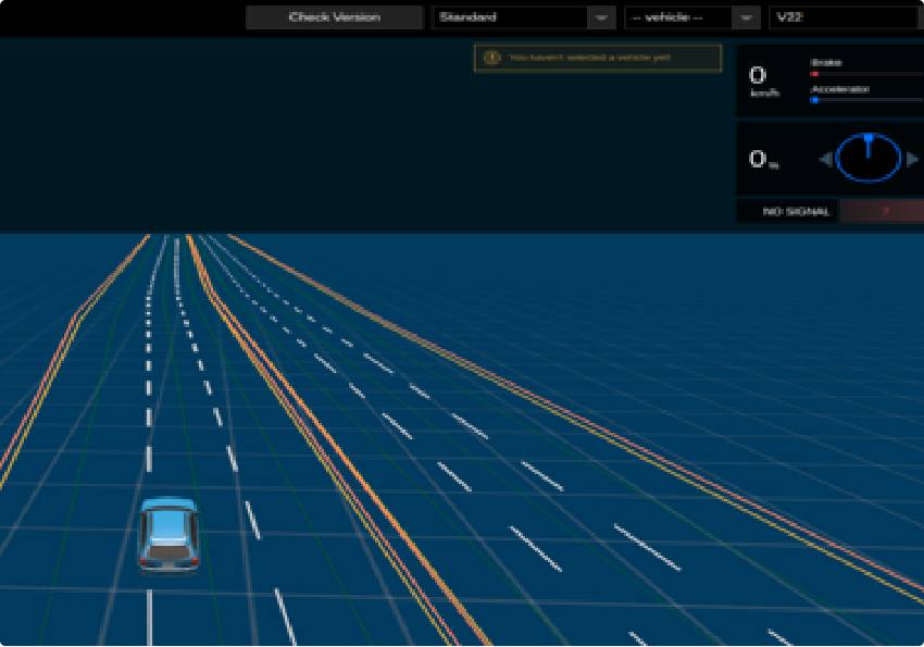
An autonomous driving system is simulated through a myriad of testing scenarios to ensure the system’s safety, security and workability. A lot of these tests are executed in simulation environments. Running testing scenarios on HD maps makes the simulation process reliable. Our HD maps are already compatible with the CARLA simulation software and we are continuously experimenting with various other open-source simulation softwares.

Data Conversion
While we already support industry-standard HD map formats, core data is maintained in a proprietary format. It makes it easy for us to convert core maps into customer-specific formats.
Core Competencies

Highly detailed
MapmyIndia HD maps are highly detailed, with lane level geometries, junctions and intersections, traffic signs, obstacles and other relevant objects at a centimetre grade precision needed for HD map applications.
Nuanced map attributes
Our highly nuanced HD map attributes provide reliable information about car surroundings with precise object location and attributes such as traffic light heights, signboard direction, road width etc.

Improving safety
MapmyIndia, with experience in road safety technology and applications, are masters in keeping HD map build computational costs under control and creating it as a reliable sensor for enhancing safe driving conditions for any autonomous system.

Cost-effective, reliable data
With our commitment towards enabling the market with cost-effective and quality-centric HD maps, we have extensively invested in the AI-assisted HD mapping process to build highly scalable, flexible and reliable data products across different geographies.
MapmyIndia HD Map - Foundational Principles
MapmyIndia HD maps are based on a set of guiding principles that provide an
overarching context to the entire pipeline beginning with planning to deliver.

Scalability
Reliability
Cost Effectiveness

Quality

Human Augumented
AI Assisted
Adherence to Standards

Precision


There's so much that Mappls MapmyIndia can do for your enterprise or individual requirements. Explore our website to learn more or request a callback/email if you'd like us to connect with you.